Finding a reliable touch screen marine GPS helps boaters stay on course, avoid hazards, and locate fuel, food, and rest stops along itineraries. This guide highlights top options that blend large, responsive displays with practical navigation features for coastal and inland waters. Each product below offers a different balance of mapping depth, sonar integration, autopilot compatibility, and multimedia capabilities to suit diverse boating styles.
Summary of selected products:
- Humminbird XPLORE 9 GPS Fish Finder with Transducer — MEGA imaging, built-in GPS, and real-time mapping.
- Garmin GPSMAP 1222 Plus — 12″ touchscreen chartplotter with worldwide basemap and NMEA connectivity.
- Garmin GPSMAP 79sc — rugged, floating handheld with bluechart mapping options.
- Garmin GHC 50 Marine Autopilot Touchscreen Display — integrated autopilot control with touchscreen interface.
- Geloo 2025 Upgraded Marine Stereo — 8″ touchscreen with CarPlay/Android Auto and IPX6 waterproofing.
Humminbird XPLORE 9 GPS Fish Finder With Transducer

Premium sonar technology defines this Humminbird model. MEGA Side Imaging+ offers a 200-foot range on both sides, while MEGA Down Imaging+ reaches depths of 200 feet for detailed underwater structures. Dual Spectrum CHIRP provides wide and narrow modes to improve fish detection in varying depths. The GPS system includes built-in mapping with Humminbird Basemap covering more than 10,000 lakes, and compatibility with LakeMaster and CoastMaster VX map cards for broader North American coverage. Real-time mapping via AutoChart Live creates depth contours, bottom hardness, and vegetation maps on the go, and eight hours of built-in recording time supports trackable trips. Compatibility with AutoChart Zero Line SD cards adds mapping flexibility for deeper customization. A robust option for anglers and boats that rely on precise underwater detail.
Garmin GPSMAP 1222 Plus 12″ Chartplotter

The GPSMAP 1222 Plus brings a large 12-inch, sunlight-readable touchscreen designed for marine environments. It offers straightforward navigation with a worldwide basemap and strong integration capabilities. J1939 engine connectivity supports linking with engines such as Yamaha, enabling unified control and data sharing. The onehelm feature facilitates connections to third-party devices and systems, including digital switching solutions. Set up a complete marine network seamlessly—from sonar and autopilots to cameras and multimedia—through NMEA 2000 and Garmin’s proprietary Garmin Marine Network. The combination of a bright display, easy-to-use interface, and broad connectivity makes it a versatile centerpiece for a modern cockpit.
Garmin GPSMAP 79sc Marine Handheld
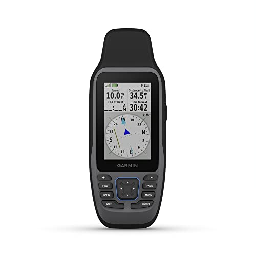
This rugged, floating handheld is designed for on-water use with a high-resolution color display and fogproof glass. It includes bluechart coastal charts preloaded and offers reliable satellite tracking with support for multiple constellations (GPS, GLONASS, Beidou, Galileo, QZSS, SBAS). The unit’s floating design reduces loss risk if dropped overboard, and it supports expanded memory for more waypoints, routes, and activities. It provides a durable, portable option for sailors, kayakers, or divers who require a reliable backup or secondary navigation tool with marine-grade durability.
Garmin GHC 50 Marine Autopilot Touchscreen Display

The GHC 50 serves as a dedicated autopilot touchscreen display, enabling intuitive steering control and integration with compatible steering systems. While primarily an autopilot component, its surface-level interface consolidates navigation commands, waypoint management, and route adjustments in one accessible panel. This device is best suited for vessels already equipped with a Garmin autopilot ecosystem seeking a centralized control interface and streamlined operation for hands-on navigation in rough seas or demanding conditions.
7” GPS Navigator For Car Truck RV With Lifetime North America Maps

This compact navigator focuses on versatile road navigation with a 7-inch touchscreen and lifetime North America map updates. It supports real-time voice guidance in multiple languages and alerts for turns, traffic lights, speed cameras, and changing speed limits. Its vehicle-size routing can optimize paths for cars, trucks, RVs, buses, and emergency vehicles, avoiding restricted roads and low-clearance routes. While not marine-specific, this device complements a broader navigation toolkit when dockside screens or backup displays are needed, and it can be a helpful portable option for off-water navigation planning and trip preparation.
Minn Kota i-Pilot Link Bluetooth Remote

The i-Pilot Link Bluetooth Remote adds flexible control for trolling motors, enabling multiple anglers to manage motor functions via a touchscreen-enabled interface. It supports Bluetooth-enabled i-Pilot Link systems (2017 and newer with Bluetooth). While not a standalone GPS device, this accessory enhances on-water navigation and motor control for powered boats using compatible i-Pilot Link ecosystems, helping crews maintain desired headings and drift control with minimal manual input.
Buying Guide: Key Purchase Considerations And Comparisons
When selecting a touch screen marine GPS system, consider display size and readability, map availability, sonar and imaging features, and how the device integrates with other onboard systems.
- Display size and visibility: A larger, high-contrast display improves legibility in bright sunlight and rough seas. Consider glare resistance and touchscreen responsiveness with wet or gloved hands.
- Mapping and chart options: Look for basemaps suitable for your cruising area, plus support for premium charts (LakeMaster, CoastMaster, Navionics, etc.). Ensure maps are updatable and offer depth contours, marinas, and hazards.
- Sonar and imaging: If fishing is a priority, models with MEGA imaging, Side Imaging, or Down Imaging provide deeper insight into underwater structures. Network compatibility for sharing sonar data across devices can add value.
- Networking and integration: NMEA 2000/NMEA 0183, Garmin Marine Network, or other ecosystems determine how easily you can connect sonar, autopilots, engine data, cameras, and remote controls. Consider future upgrade paths.
- Autopilot compatibility: For vessels using autopilot, ensure the display supports autopilot control and integrates with existing helm systems for seamless steering adjustments.
- Portability vs. installation: Handheld devices offer backup navigation and portability, while fixed displays integrate into the helm. Assess space, power requirements, and intended installation environment.
- Durability and water protection: Marine environments demand waterproofing (IP ratings) and rugged construction. Floating handhelds are advantageous for risk of immersion.
- Multimedia and smart features: Some units offer CarPlay/Android Auto, Bluetooth connectivity, and media playback, enhancing onboard infotainment beyond navigation.
In summary, the best choice depends on how you fish, where you boat, and how deeply you want to integrate navigation with other onboard systems. Larger chartplotters with robust sonar options suit serious anglers and coastal cruisers, while rugged handhelds and autopilot displays provide reliable backups and streamlined helm control. Always verify compatibility with your vessel’s existing electronics and ensure your chosen model supports the maps and features you rely on most on the water.